On Tuesday, a severe weather system is expected to strike parts of the southern United States, particularly affecting Louisiana, Mississippi, Alabama, and Arkansas. This system has raised significant concerns as it brings the potential for dangerous thunderstorms, tornadoes, heavy rain, and flooding. Meteorologists are urging residents in these states to stay alert and prepare for potentially life-threatening weather conditions.
What to Expect on Tuesday
The National Weather Service (NWS) has issued a warning about the risks posed by this system. Meteorologists predict that severe weather could start by midday and continue into the evening. The primary hazards include:
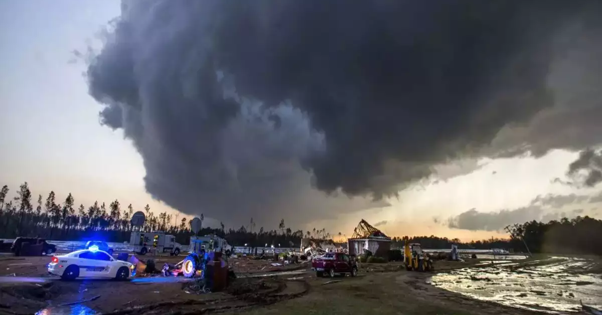
- Tornadoes: The potential for tornadoes is high, with the possibility of some becoming strong. These tornadoes could develop rapidly, leaving little time for residents to take shelter. Tornadoes with wind speeds of up to 100 mph or more are not out of the question, making them particularly dangerous for those in the affected areas.
- Hail: Large hail is another risk associated with these thunderstorms. Hailstones large enough to damage vehicles, roofs, windows, and crops could fall across these states, causing extensive damage.
- Wind Gusts: Winds in excess of 60 mph are likely, which could cause trees to fall, power lines to snap, and roofs to be damaged. High winds can be just as dangerous as tornadoes when they uproot trees and send debris flying through the air.
- Flooding: With the heavy rainfall expected in many regions, flash flooding is a concern. Areas that have already been saturated by previous storms or heavy rains may experience severe flooding. Rivers, creeks, and streams could overflow, leading to widespread water damage.
Areas at Risk
The most affected areas are likely to be parts of Louisiana, Mississippi, Alabama, and Arkansas. Here’s a breakdown of where the severe weather will have the most impact:
- Louisiana: The central and eastern parts of Louisiana are under a high risk for severe weather. Cities like Baton Rouge and New Orleans are expected to face thunderstorms, strong winds, and potential tornadoes. The risk of flash flooding is also high, especially in low-lying areas prone to water accumulation.
- Mississippi: Central and southern Mississippi will face the worst of the storms. The cities of Jackson, Biloxi, and Gulfport are likely to experience severe thunderstorms, tornadoes, and possibly hail. Coastal areas are especially vulnerable to heavy rain and strong winds, which could lead to storm surges in some regions.
- Alabama: Alabama is under a moderate risk, but areas such as Birmingham and Montgomery will be in the path of these dangerous storms. Tornadoes, damaging winds, and heavy rain will pose significant threats throughout the day. People in these cities should prepare for the possibility of power outages and property damage.
- Arkansas: The northern and central regions of Arkansas are most at risk. Little Rock, Conway, and other central areas could see severe thunderstorms and tornadoes. High winds and flooding are expected to be a significant concern as the storm moves through this region.
How to Stay Safe During Severe Weather
While these storms are powerful and can be unpredictable, there are steps you can take to stay safe. Here are some essential safety tips for residents of the affected areas:
- Stay Informed: Keeping up with weather updates is crucial. Watch your local news, follow the National Weather Service on social media, and use weather apps to stay up-to-date on any changes in the storm’s progress. Be aware of tornado watches and warnings, and take them seriously.
- Create an Emergency Plan: If you don’t already have one, now is the time to prepare one for your family. Choose a safe room or area in your house away from windows and exterior walls. If you live in a mobile home, identify the nearest sturdy shelter and be ready to relocate if necessary.
- Prepare an Emergency Kit: It’s always a good idea to keep an emergency kit stocked with essentials. Items to include are bottled water, non-perishable food, flashlights, batteries, a first-aid kit, important documents, and medications. If you lose power or are forced to shelter for an extended period, these supplies will come in handy.
- Secure Outdoor Objects: High winds can turn everyday objects into dangerous projectiles. Secure outdoor furniture, trash bins, and anything else that could be blown away. Move cars to a garage or sheltered area to prevent them from being damaged by hail or fallen trees.
- Know When to Take Shelter: If a tornado warning is issued, seek shelter immediately. Go to a basement or an interior room on the lowest floor, away from windows. If you’re caught outside, find the closest sturdy building to shelter in until the storm passes.
- Follow Local Authorities: Listen to local emergency officials and follow any evacuation or shelter-in-place orders. They have the best information about the specific threats in your area and can guide you in making the safest choices.
Why Is This Happening?
This weather system is caused by a low-pressure area moving through the region. Low-pressure systems are known for intensifying storms, especially when they meet warm, moist air from the Gulf of Mexico.
The combination of these factors creates unstable conditions in the atmosphere, which leads to the development of thunderstorms, tornadoes, and strong winds. Such systems are common in the spring, as warm and cool air masses interact in ways that fuel severe weather.
Climate Change and Severe Weather
Experts have noted that severe weather events like these are becoming more frequent and intense due to climate change. Rising global temperatures have led to more extreme weather patterns, with storms growing stronger and more unpredictable.

While this storm is part of a natural weather cycle, climate change is contributing to the severity and frequency of such events. Communities in the affected regions must adapt by improving storm preparedness, strengthening infrastructure, and taking steps to mitigate the impacts of climate-related disasters.
Preparing for the Future
While today’s storm requires immediate action, it’s important to think ahead. Building resilient infrastructure, such as better storm drainage systems and flood protection measures, will help communities withstand future extreme weather. Individuals can also take steps to protect their homes by reinforcing roofs, windows, and doors to withstand stronger winds.
Disclaimer: This article has been meticulously fact-checked by our team to ensure accuracy and uphold transparency. We strive to deliver trustworthy and dependable content to our readers.


